Thanks to his experience and strong relationships with local lodge owners, we spent very little time between arriving at a lodge and relaxing after the day’s challenges. Comfortable rooms, well-planned meals, and the chance to rest fully each evening greatly enhanced our enjoyment of the Ghorepani–Ghandruk Trek in Nepal. Dammaru’s careful attention to these details made each day’s end as rewarding as the trekking itself.
Manaslu Trekking 21 Days
Facts of the trip
| Trip Code: | MSL 12 |
| Trip Duration: | 21 days |
| Max. Altitude: | 5464m |
| Grade: | Challenging |
| Program Type: | Trekking |
| Trek Start Point: | Gorkha |
| Trek End Point: | Muktinath |
| Accommodation: | Teahouse |
| Meals: | Breakfast, lunch , Dinner with tea/coffee |
| Mode of Travel: | Adventures |
| Transportation: | Car / Bus |
| Minimum Pax: | 05 |
| Best season: | February to May / September to November |
Manaslu Trekking 21 Days – Manaslu Circuit Trek Overview
Introduction
The Manaslu Circuit Trek is one of the most beautiful and exciting trekking journeys in Nepal. This 21-day Manaslu Trekking adventure takes you around the magnificent Manaslu Massif (8,163 m), the eighth-highest mountain in the world. The trail offers a wonderful combination of natural beauty, cultural discovery, peaceful surroundings, and a true Himalayan experience.
Unlike many popular trekking routes in Nepal, the Manaslu Circuit Trek remains less crowded and more peaceful. Therefore, it is an excellent choice for travelers who want to explore a remote Himalayan region away from busy trails. During the journey, trekkers pass through traditional villages, green valleys, ancient monasteries, high mountain landscapes, and beautiful forests.
Moreover, the trek provides a close connection with local lifestyles. The route passes through both Hindu and Buddhist communities where people still follow traditional customs. Because of this unique combination of nature and culture, the Manaslu Trekking route has become one of the most rewarding adventures in Nepal.
Why Choose the Manaslu Circuit Trek?
The Manaslu Circuit Trek is perfect for those who are searching for adventure, peace, and authentic mountain experiences. The trail is less commercial compared to the Everest and Annapurna regions. As a result, trekkers can enjoy quiet paths, untouched landscapes, and meaningful interactions with local people.
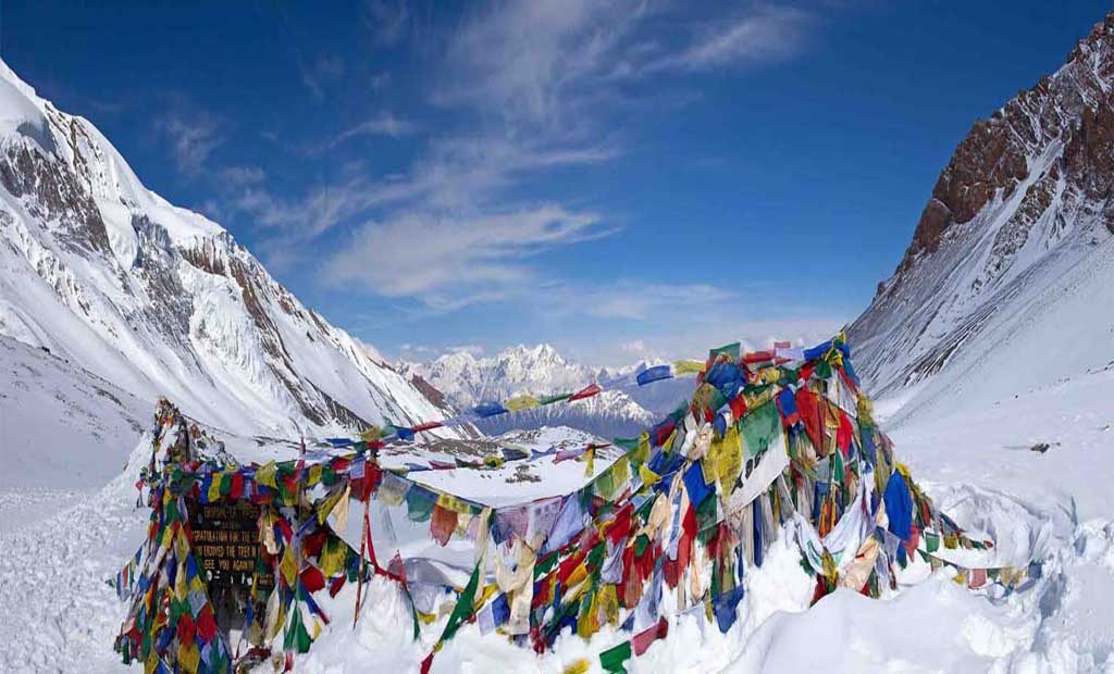
One of the main attractions of this journey is the crossing of Larkya La Pass (5,160 m). This high mountain pass is challenging, but it rewards trekkers with incredible views of Manaslu and surrounding Himalayan peaks. Furthermore, the route includes ancient villages, Buddhist monasteries, prayer flags, mani walls, and beautiful mountain scenery.
The trek also passes through different ecological zones. You can experience warm green valleys, dense forests, alpine landscapes, and snowy mountain areas within one journey. Therefore, the Manaslu Circuit Trek offers a complete Himalayan experience.
Cultural and Natural Highlights
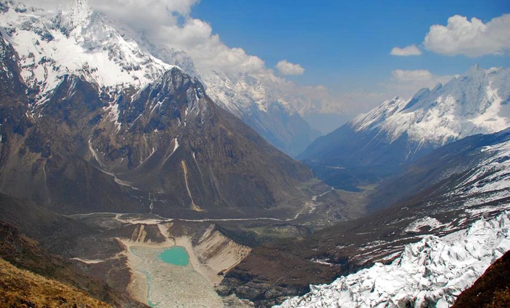
The Manaslu region is rich in both cultural and natural treasures. The trail follows the Budhi Gandaki River and moves through dramatic landscapes filled with waterfalls, forests, cliffs, and glaciers.
The region is home to different ethnic groups, including Gurung, Tamang, and Tibetan-origin communities. Their lifestyle, traditions, and religious practices create a special atmosphere throughout the trek.
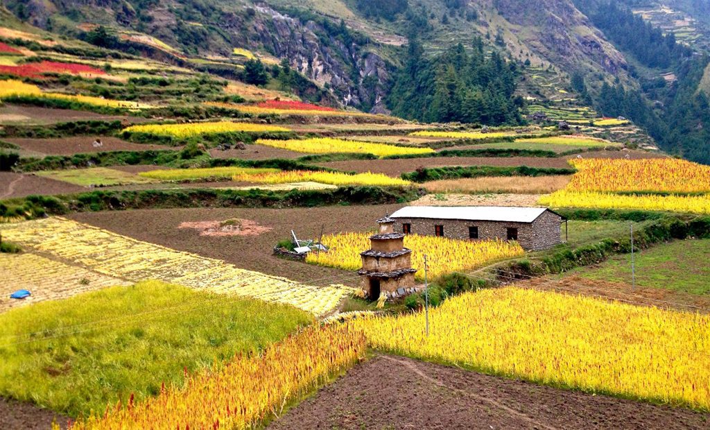
In addition, the villages along the route provide a chance to understand traditional mountain life. Local people depend on farming, animal raising, and small businesses. Their simple lifestyle and warm hospitality make the journey more memorable.
The natural beauty of the area is equally impressive. Snow-covered mountains, deep valleys, colorful forests, and peaceful rivers create a stunning Himalayan environment.
Trekking Regulations and Permits
The Manaslu Circuit Trek is a restricted area trek in Nepal. This means trekkers must follow special rules before entering the region. Solo trekking is not allowed. At least two trekkers and a registered local guide are required for this journey.
The restriction was introduced to protect the environment and preserve the unique culture of the region. Until 1991, this area was closed to foreign visitors. After opening, the region slowly became popular among adventure travelers.
A special restricted area permit is required for the Manaslu Trekking route. The permit cost changes depending on the season. During October and November, the fee is higher because this is the peak trekking season. During other months, the cost is lower.
Additionally, trekkers need a Manaslu Conservation Area Permit and other required documents before starting the trek.
Starting Point and Accessibility
The Manaslu Circuit Trek usually begins from the lower hills of Nepal. The common starting point is Machha Khola after driving from Kathmandu. Some travelers also use Gorkha or nearby areas as entry points depending on road conditions and trekking plans.
The journey begins with a scenic drive through countryside landscapes. Along the way, you can see rivers, farmland, villages, and green hills. Although the road journey can be long, it prepares you for the remote mountain adventure ahead.
Because the region is far from major cities, the trail feels peaceful and natural from the beginning.
Trek Conditions and Challenges
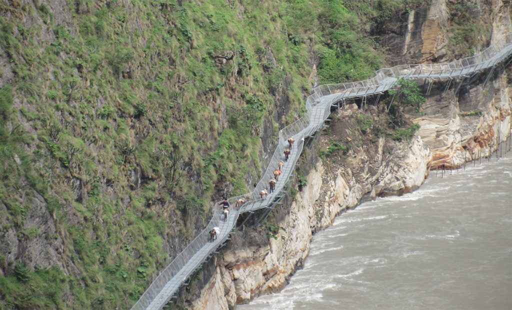
The Manaslu Trekking route is considered a challenging Himalayan adventure. The trail includes steep climbs, rocky paths, narrow sections, and high-altitude areas. Some parts of the trail pass above rivers and cliffs, creating an exciting experience.
The biggest challenge is crossing Larkya La Pass at 5,160 meters. The pass is not technically difficult, but the high altitude, cold weather, and long walking hours require good preparation.
Unlike easier trekking routes, rescue services and transportation facilities are limited in this region. Therefore, trekkers should have proper equipment, physical fitness, and a good understanding of high-altitude conditions.
However, the challenges are worth facing because the views and experiences are unforgettable.
Tibetan Influence and Cultural Experience
One of the most special parts of the Manaslu Circuit Trek is the strong Tibetan influence. The upper Budhi Gandaki Valley, especially areas like Samagaon and Samdo, is home to communities with Tibetan heritage.
The people in this region speak Tibetan-influenced languages and follow Tibetan Buddhist traditions. You can see traditional houses, prayer wheels, monasteries, and colorful prayer flags throughout the villages.
The connection with Tibet is also visible through trade and cultural exchange. Many villages still maintain old traditions that have existed for centuries.
This cultural richness makes the Manaslu region a unique destination for travelers interested in history, spirituality, and mountain life.
Mt. Manaslu (8,163 m) Views
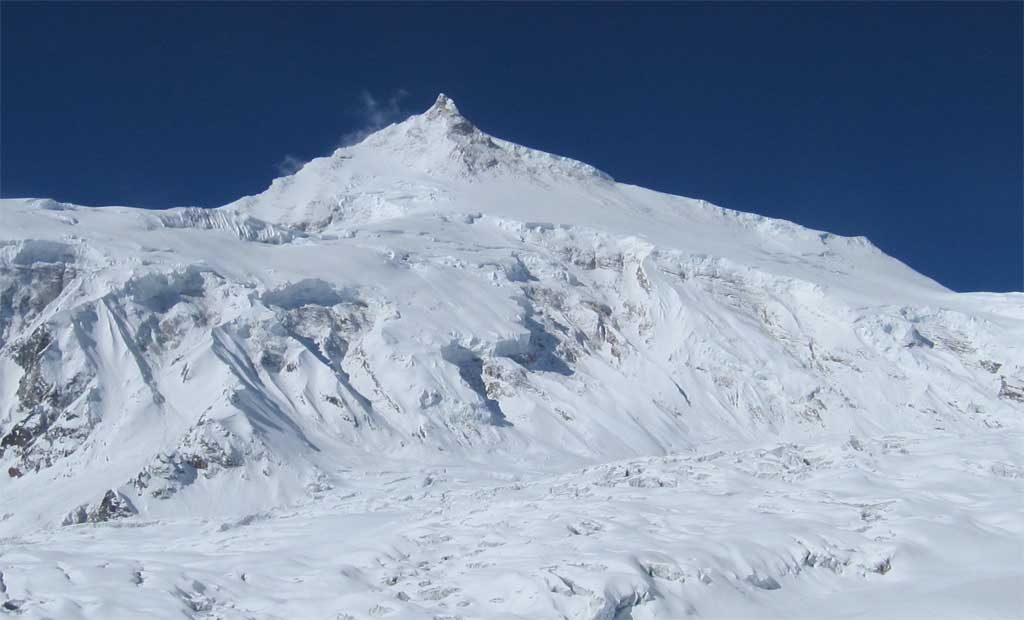
The highlight of the trek is the magnificent view of Mount Manaslu. This giant Himalayan peak dominates the landscape throughout much of the journey.
Trekkers can enjoy different perspectives of Manaslu from villages, viewpoints, and mountain trails. Sunrise and sunset views are especially impressive when the golden light touches the snowy peak.
Besides Manaslu, the trail also offers views of other Himalayan mountains, including Himlung Himal, Kang Guru, and Annapurna II.
These breathtaking views make the Manaslu Circuit Trek one of the most scenic trekking routes in Nepal.
Larkya La Pass (5,160 m)
The Larkya La Pass is the highest point of the Manaslu Trekking journey. Crossing this pass is one of the most exciting moments of the adventure.
The climb starts early in the morning because weather conditions can change quickly. Although the walk is demanding, the panoramic mountain views from the top create a lifetime memory.
From the pass, trekkers can admire a wide Himalayan panorama with snow-covered peaks, glaciers, and dramatic valleys.
Therefore, Larkya La Pass is not only a physical challenge but also a rewarding achievement.
Remote and Peaceful Trail
Compared with the crowded Everest Base Camp and Annapurna Circuit routes, the Manaslu Circuit Trek offers a quieter experience.
The limited number of trekkers helps preserve the natural environment and local traditions. You can walk through peaceful forests, empty mountain paths, and traditional villages without large crowds.
For travelers who want a more authentic Himalayan adventure, this route provides the perfect balance of exploration and solitude.
Birendra Tal Lake
Near Samagaon, trekkers can visit the beautiful Birendra Tal Lake. This glacial lake sits below the impressive Manaslu mountain range.
The clear blue water reflects the surrounding snowy peaks, creating a peaceful and beautiful atmosphere. It is an excellent place to rest, take photographs, and enjoy the natural surroundings.
The lake adds another special highlight to the Manaslu Tsum Valley Trekking 19 daysTrekking experience.
Tsum Valley Extension
Trekkers who want more cultural exploration can add the Tsum Valley extension to their journey.
Tsum Valley is a hidden Himalayan valley known for ancient monasteries, Buddhist traditions, and peaceful villages. The valley provides a deeper look into Tibetan culture and mountain spirituality.
With fewer visitors, Tsum Valley offers a quiet and meaningful experience.
Wildlife and Nature
The Manaslu Conservation Area protects a wide range of plants and animals. The region is home to many rare species, including Himalayan tahr, snow leopard, and red panda.
The forests are filled with birds, colorful flowers, and medicinal plants. As the altitude changes, the vegetation also changes from tropical forests to alpine landscapes.
Nature lovers will enjoy the incredible biodiversity found along the trail.
Vegetation of the Manaslu Region
The vegetation of the Manaslu region changes dramatically with altitude.
At lower elevations, the trail passes through subtropical forests with sal trees, pine forests, bamboo, and farmland. These areas are green and full of life.
As the altitude increases, trekkers enter temperate forests with oak, maple, rhododendron, and many medicinal plants. During spring, rhododendron flowers create beautiful colors along the trail.
Higher areas near Samagaon and Samdo have alpine vegetation. Juniper, small shrubs, and grasslands dominate the landscape. Near Larkya La Pass, vegetation becomes very limited because of cold temperatures and strong winds.
This variety of landscapes makes the Manaslu Circuit Trek visually fascinating.
Weather and Atmosphere
The weather in the Manaslu Trekking area changes according to altitude and season.
Lower areas are warmer and more humid, while higher regions are cold and dry. At high altitudes, temperatures can drop below freezing, especially during nighttime.
Spring and autumn are the best seasons for trekking. Spring offers blooming flowers and clear mountain views. Autumn provides stable weather and excellent visibility.
Winter brings heavy snow in high areas, especially around the Larkya La Pass. Monsoon brings rain, slippery trails, and possible landslides in lower sections.
Therefore, choosing the right season is important for a safe and enjoyable journey.
Tea House Trekking Experience
The Manaslu Circuit Trek is a tea house trek. Along the route, trekkers can stay in local lodges and small guesthouses.
These tea houses provide basic but comfortable accommodation and delicious Nepali meals. Staying in local lodges allows travelers to experience mountain hospitality.
Sharing stories with locals and other trekkers creates a warm and friendly atmosphere after long walking days.
Why Join a Nepali Freelance Guide for the Manaslu Trekking?
Exploring the Manaslu Circuit Trek with a Nepal freelance guide provides a more personal and flexible travel experience.
A local freelance guide understands the trails, culture, weather, and local conditions. They can help arrange permits, accommodations, transportation, and necessary trekking support.
With a Nepal freelance guide, you can enjoy a customized itinerary based on your interests, walking ability, and travel style. You also avoid unnecessary middle costs and receive direct local support.
A professional guide helps you travel safely through remote areas while sharing knowledge about the mountains, villages, traditions, and history.
Choosing a freelance guide also supports local tourism and creates a closer connection with Nepalese communities.
Conclusion
The Manaslu Circuit Trek is one of Nepal’s most rewarding Himalayan journeys. It combines adventure, culture, nature, and peaceful mountain experiences in one incredible route.
From the impressive views of Mount Manaslu to the challenging crossing of Larkya La Pass, every part of the trek offers something special. The route takes you through traditional villages, ancient Buddhist landscapes, beautiful forests, and remote valleys.
Moreover, the untouched beauty of the Manaslu region makes this trek different from other popular routes. It is an ideal choice for travelers who want fewer crowds, authentic culture, and a true Himalayan adventure.
With the support of an experienced Nepali freelance guide, your Manaslu Trekking journey
The Manaslu Circuit is more than just a trek. It is a journey through nature, tradition, and the heart of the Himalayas.
Day 01: Kathmandu to Dhading to Kafalpani
Day 02: Kafalpani to Arughat
Day 03: Aarughat to Sati Khola
Day 04: Sati Khola to Labu Besi
Day 05: Labu Besi to Doban
Day 06: Doban to Jagat
Day 07: Jagat to Serson
Day 08: Serson to Deng
Day 09: Deng to Ghap
Day 10: Ghap to namrung
Day 11: Namrung to Shya
Day 12: Shya to Gompa
Day 13: Sama Gompa to Samdo
Day 14: Samdo to Larkya Rest house
Day 15: Larkya Rest house to Bimtang
Day 16: Bimatang to Gho
Day 17: Gho to Dharapani
Day 18: Dharapani to Syange
Day 19: Syange to Bulbule
Day 20: Bulbule to Besishahar
Day 21: Besi Shahr to Kathmandu
Day 01: Kathmandu to Dhading to Kafalpani: Drive from Kathmandu to Dhading Besi and cross the dense sal forest along the way to Buchung village in a steep valley, then enter Dhading village from where peaks of Ganesh Himal are visible to the north. The trail goes ahead to Nigalapani, from where the views of Annapurna II and Manaslu can be seen. Afterward, the trail crests the ridge at Kafalpani (1350 m). The beautiful sights of Annapurna, Manaslu (8163 m), Shringi Himal (7187 m), and Ganesh Himal (7406 m) are visible from here.
Day 02: Kafalpani to Aarughat: On this day, the trek descends to Chainpur and again descends steeply to a stream, then crosses a long suspension bridge over Ankhu Khola and climbs to Salyan Taar after walking a few km. The trail enters the valley of Budhi Gandaki. The flat trail through the forest reaches Doren and then Aarughat. There is a trail junction here that turns west across the bridge over Budhi Gandaki and continues the trek; the eastern route is joining from Trishuli Bazaar. West of the bridge through the bazaar, there is a checkpoint. Then, pass the hydroelectrics. power plant through rice and millet fields and reach Aarughat to rest overnight.
Day 03: Aarughat to Sati Khola. The trek starts to go ahead to Sati Khola via Sante Bazaar and Budhi Gandaki Valley and reaches Koirpani, a small village of Magar and Gurung. The trail descends to Ahati Khola. There is a small waterfall just above the trail; a larger waterfall with a 60-meter drop is visible by climbing upstream. This valley is famous for honey, which is harvested in a manner as described in the book “Honey Hunters of Nepal.”
Day 04: Sati Khola to Labu Besi. After crossing the bridge, the trek climbs up onto a ridge above the huge rapids of Budhi Gandaki and reaches Khorsaani. Then it, the trail, gets a bit precarious as it passes over a big rock and crosses a stream. The rocky trail then goes up and down through a large stand of nettles, passes tropical waterfalls, and again backs down to the bank of Budhi Gandaki. The trek goes up again on a steep rocky trail and down, then up around to the Gurung village of Labu Besi and rests overnight.
Day 05: Labu Besi to Doban: The trek continues forward to Machha Khola after crossing several streams on the way and reaches the place where a cable ropeway is hanging over Budhi Gandaki; it should be crossed in a small cable car called “Girling.” The trail again forwards to Doban Khola via Khorlavesi, Tatopani, etc.
Day 06: Doban to Jagat: The route climbs on a rugged rocky trail to Duman. Then passes the villages of Yaru Khola and Thado Bharyang and crosses Budhi Gandaki again and climbs over a ridge; treks along the river for a while and reaches the compact village of Jagat at 1410 meters.
Day 07: Jagat to Serson: The trek climbs over a rocky ridge up to Salleri. Shringi Himal offers good views from this village. The trail descends to Setibas (Tara), a Gurung village influenced by Tibetan culture. Continuing upstream, the trail follows the best and new route to Manaslu via Ngyuak (Nyak) and climbs up to Philim (Dodang) at 1550 meters. The trail that then leads to Ganesh Himal is called Tsum. It is still off-limits to foreigners. This village of Tsum is inhabited by Tibetans and is towards Tibet across two passes ahead of the Shar Khola (East River) Valley. Later on, the trail reaches Serson.
Day 08: Serson to Deng: After Serson, the trail enters a steep uninhabited gorge and descends through grassy slopes dotted with tall pine trees. Then, the trail hangs on a cliff after crossing the Budi Gandaki. The tiny village Deng comes after crossing a bamboo forest and Deng Khola (river)
Day 09: Deng to Ghap: today the trail re-crosses Budi Gandaki and climbs up, then passes a waterfall. After crossing a stream it continues to climb ahead before dropping to Shring Khola crosses it and climbs steeply to reach Ghap (task). Many of the carvings of Buddha in various meditative poses and others are of the Tibetan saint Milarepa, who is said to have traveled and meditated in this valley.
Day 10: Ghap to Namrung: The trail then crosses a 26-meter-long bridge over the Budi Gandaki at 2100 meters and passes many stones to enter into the woods. Then, the trail climbs two long main walls, and a waterfall will be on the way to the village in the Budi Gandaki Valley, which is a trading route to Tibet. The trek climbs over a big rock and continues up through deep fir and rhododendron. The forest enters Namrung (Nsamdru) through a stone archway at 2600 meters; there are excellent camps in the forest. Another part of Namrung remains across the bridge.
Day 11: Namrung to Shya: After Namrung, the trail follows the Nupri region, a region of Tibetan immigration. On the way to village Li at 2900 meters, the trail passes village Barcham (Bartsam) and the forest of fire and rhododendron. The trail leaves the village and crosses Hinan Khola and reaches Sho Sho, where children demand “shim,” a Tibetan word for sweets or candy. After leaving the Budi Gandaki valley, the spectacular views of Mt. Manaslu, Manaslu North (7154 m), and Naike Peak come into sight. The trail then follows to Lho (Lo) at 3100 3100meters pass Shrimp, a small settlement. Lho is a big village with a gompa (monastery), a stone archway at the entrance of a Tibetan-style chorten, and a huge mani wall. The trail drops down to cross Damonan Khola, starts to ascend again, and finally emerges onto a plateau at Shya (3520 m) with wide views of Himal Chuli, Ngadi Chuli, and Manaslu.
Day 12: Shya to Gompa: The trail crosses a ridge and descends onto a rock-strewn moraine, then emerges onto a ridge overlooking pastures and fields of Samagaon (Ro). The Samagaon Gompa is nestled against a wooded moraine at the far end of the valley. Spare a day to climb the ridge to the south of Samagaon to the Pung-Gyen Gompa hidden behind the ridge in front of Manaslu. The Japanese call this Honsanso Gompa. An avalanche destroyed it in the winter of 1953, killing 18 inhabitants.
Day 13: Sama Gompa to Samdo: The trail descends to Budhi Gandaki and leads to Manaslu base camp. The Larkya La trail passes several Manmu walls and reaches Kermo Kharka after crossing the juniper and birch forests. The trail then climbs steeply to find Samdo nestled behind a bridge at 3860m. Somewhere in the village, a police checkpoint lurks; a major trade route to Tibet heads ahead east through the village over Lajyang La at 5098 m. A day’s walk from here.
Day 14: Samdo to Larkya Resthouse: The trek descends to the river and crosses it, then proceeds on to climb to Larkya La. Again, climb gently through Juniper and Tundra opposite to Larkya La Glacier. The trail gets steeper and climbs the side of the ridge to about 4000 m. Where there is a viewpoint at the edge of a huge gorge. The trail climbs in and out and reaches the only shelter on the route to the pass, a rest house at 4480.
Day 15: Larkya Resthouse to Bimtang: Starting up the ridge in front of the rest house, the trail reaches the top of the moraine at 7400 m. And climbs steeply to the pass at 5100m. It takes about 3/4 of an hour. To reach the pass, it is best to start earlier. The tremendous views of Himlung Himal (7126 m). Cheo Himal (6820 m.), Gyaji Kung, Kang Guru (6981 m.), and Annapurna II (7937 m.) can be seen on the west from here. Then the trail descends to Bimtang (3720 m.), which means “Plain of Sand” in the Tibetan language. This is a huge valley surrounded by high peaks.
Day 16: Bimatang to Gho: The trek descends to Dudh Khola and reaches Gho at 2560 m., crossing pine and rhododendron forests via Hompuk and Karchep village. At the foot of the valley, part of Lamjung peak above the Marsyangdi valley comes into sight.
Day 17: Go to Dharapani: The trail continues through the fields with rhododendron oak forests to Dharapani via Tilje (Tiljet) and Thonje (Thangjet) villages. In Thonje, the Sirdar Liaison Officer will contact the police to show the collected garbage to obtain a clearance certificate. Afterward, the trek follows the trail to Dharapani (1920 m) for rest overnight.
Day 18: Dharapani to Syange: On this day the trek goes south through the steep part of the Marshyangdi Gorge.
Day 19: Syange to Bulbule: The trek again follows the Marshyangdi south and enters into terraced rice field countryside.
Day 20: Bulbule to Besishahar: Today, the trek goes ahead to Besishahar and rests overnight.
Day 21: Besi Sahar to Kathmandu: From Beshi Shahar vehicles are available to Kathmandu.
| Start Date | End Date | Price In US Dollar($) | AVAILABILITY | Booking |
|---|
AVAILABILITY OPTIONS
OPENED: This date is available and open for bookings.LIMITED: There are very limited number of available places on this departure. Immediate booking.
GUARANTEED: We have reached minimum numbers and this trip is guaranteed to depart.
CLOSED: This date is currently unavailable. Please contact us, if you are interested in travelling on this date.
Your Program Duration = 21 days Days
All the Prices are in GBP (£) Per Person.
Cost Include
COST INCLUDED
- All airport and hotel transfers
- Conservation and TIMS permit
- Kathmandu to Bashisahar Bus ticket and Bashisahar to Chame Jeep
- Jomsom to Pokhara flight ticket for guest and guide
- Jomsom to Pokhara bus ticket for all staff
- Accommodation in Pokhara
- Pokhara to Kathmandu bus ticket.
- Accommodation, food, & Tea/coffee during treks
- including salary, insurance, equipment, bus transportation, flight fare, food, and lodging
- Porter:- including salary, insurance, equipment, bus transportation, food, and lodging
- All government and local taAround Manaslu, trekking is about the Manaslu Massif (8,163 m), the eighth-highest mountain in the world. The Manaslu Circuit Trek is a less crowded route compared to others in Nepal, passing through traditional villages with Hindu and Buddhist settlements. This trek offers an unforgettable journey through one of Nepal’s most remote and pristine landscapes. Why Choose the Manaslu Circuit Trek?
The Manaslu Circuit Trek provides a perfect blend of adventure and solitude, rich cultural heritage, breathtaking mountain views, and diverse ecosystems. Unlike the busier Everest and Annapurna trails, Manaslu remains relatively untouched, offering a more authentic Himalayan experience. Crossing the Larkya La Pass (5,160 m) is challenging but rewarding, revealing panoramic views of Manaslu and surrounding peaks. The journey includes encounters with Tibetan-influenced villages, ancient monasteries, and diverse wildlife, adding immense charm.Cultural and Natural Highlights
For those seeking an off-the-beaten-path trek rich in culture and dramatic landscapes, the Manaslu Circuit is the perfect choice. It promises solitude, adventure, and a deep connection with Nepal’s natural and cultural beauty. The region features stunning landscapes, green countryside, lush forests, and enormous glaciers alongside majestic snow-capped peaks.Trekking Regulations and Permits
The Manaslu Circuit Trek is a restricted area trek. Solo trekking is not allowed—you need at least two trekkers and a registered local trekking guide. Entry was restricted until 1991. It became popular after a Japanese expedition successfully climbed Manaslu, earning it the nickname “Japanese Mountain.”Permits cost USD $90 per person per week from October to November and USD $75 per person per week during the rest of the year.Starting Points and Accessibility
The trek typically begins from Gorkha or Trishuli Bazaar in Dhading. Trishuli Bazaar and Dhunche serve as alternative entry points, with early morning bus departures from Kathmandu. These towns offer convenient starting points for exploring the Manaslu region.Trek Conditions and Challenges
The trail is rough, steep, and often clings to cliffs high above rivers. While the Larkya La Pass is not technically difficult, the remoteness of the area and lack of rescue services make the trek physically demanding. It’s not suitable for those expecting easy access or support facilities.Tibetan Influence and Cultural Immersion
The trek passes through Nupri in the upper Budhi Gandaki, home to Tibetan descendants. Their language, dress, and customs are purely Tibetan, and trade with Tibet still continues today. The mountain views in Nupri are sensational, and Larkya La Pass is considered one of the most dramatic in the Himalayas. Tibetan influence dominates the region, with many places retaining Tibetan rather than Nepali names
Cost Exclude
COST IS NOT INCLUDED
- Food in Kathmandu (Lunch & Dinner)
- Pokhara to Kathmandu flight ticket
- Nepal Visa fee
- International airfare from your country to Kathmandu and from Kathmandu
- Extra night accommodation in Kathmandu
- Travel and rescue insurance if guests get mountain sickness and need rescue helicopters.
- Personal expenses example (phone calls, laundry service, bar bills, battery recharge, extra porters, bottle of boiled water, shower, etc.)
- Tips for guide and porters
our testimonials
-
Testimonial from Bell Howse with the Hothouse Group Australia
Dammaru Niraula was our guide and confidant for our recent visit to Nepal. We went on a humanitarian visit to build a hothouse in the village of Phortse in the Khumbu region of Nepal but also included some trekking on a personal level before and after our project.…
-
Testimonial Overview: Ian Thwaity, Australia
This testimonial is provided by Ian Thwaity from Australia, who has worked closely with Dammaru Prasad Niraula, a freelance trekking guide and trip leader from Nepal, over a period of three years. Through multiple treks and a…
-
Dear Dammaru I have been trekking to Ghorepani poon hill on Jan 07 for 6 days with Mr. Dammaru. Poonhill is so beautiful, so all I can do is just taking pictures on poon hill. If you were planning to trek in Nepal, I…
-
Overview: Philip Pomeroy Holcot, Northamptonshire, UK.
Introduction: A Memorable Journey to the Annapurna Circuit
In 2004, I was fortunate to join a close-knit group of nine friends from Northamptonshire in the United Kingdom on the Annapurna Circuit Trek in Nepal. Together, we set out on what became one of…
-
Overview: Peter Smith & Jane Fairlie,
South Australia Ghorepani–Ghandruk Trek, Nepal (October 2006)
Introduction:
The
-
Testimonial from Bell Howse with the Hothouse Group Australia
Dammaru Niraula was our guide and confidant for our recent visit to Nepal. We went on a humanitarian visit to build a hothouse in the village of Phortse in the Khumbu region of Nepal but also included some trekking on a personal level before and after our project. Dammaru was a vital link in getting the project off the ground and then as a support person in Nepal before, during, and after. He completed the following tasks with the utmost professionalism and patience. Arranged the transfer of a large number of funds from an Australian bank account to a Nepalese bank account. Communications with the village before we arrived to ensure the walls were built. Organized our itinerary and necessary bookings for the trekking part of our journey for 8 adults. Once we arrived in Nepal, he then assisted us in purchasing all the gear we needed for the finishing of the hothouse. e.g., polycarbonate roof sheeting and the many other bits of hardware necessary. Transport of the roofing, etc., to Phortse village via helicopter, plane, yak, and porter. As well as being a part of the project, Dammaru also was our trekking guide for the duration of our trip of 5 weeks. He organized everything for us from the hotel in Kathmandu and everything in between our trek to base camp. He is honest and reliable and always puts the customer first. I would have no hesitation in recommending Dammaru to anyone who is considering a trip to Nepal.
-
Testimonial Overview: Ian Thwaity, Australia
This testimonial is provided by Ian Thwaity from Australia, who has worked closely with Dammaru Prasad Niraula, a freelance trekking guide and trip leader from Nepal, over a period of three years. Through multiple treks and a major humanitarian project in the Solu Khumbu region, Ian experienced Dammaru’s leadership, professionalism, and personal integrity firsthand.
Long-Term Association with Dammaru Niraula
I have had an association with Dammaru Niraula over the last three years, during which time I completed two significant trekking journeys under his guidance. From the very beginning, it was clear that Dammaru was not only an experienced trekking guide but also someone deeply committed to responsible trekking, safety, and community welfare.
Our relationship developed through shared challenges in remote Himalayan terrain and through collaboration on a long-term community project. Over time, trust and respect naturally grew, based on his consistent performance and genuine character.
First Trek Experience: Gokyo–Phortse–Everest Base Camp
My first trek with Dammaru Niraula was in the Solu Khumbu region, following a thoughtfully designed route through Gokyo, Phortse, and Everest Base Camp. This area is known for its rugged landscapes, traditional Sherpa settlements, and dramatic high-mountain scenery. From the outset, our group requested an itinerary that avoided the main tourist trails wherever possible and included more remote and less-traveled sections of the region.
Dammaru carefully tailored the trek to meet these expectations. His planning reflected a deep understanding of local geography, seasonal weather patterns, altitude considerations, and logistical challenges. The chosen route allowed us to cross quieter trails and experience a more authentic side of the Himalayas, while still reaching iconic destinations such as Gokyo and Everest Base Camp.
Throughout the journey, his knowledge of the region was evident in every decision. The balance between adventure, safety, and cultural exposure was handled with great care. By keeping us away from crowded trekking corridors whenever possible, Dammaru delivered a trekking experience that felt personal, peaceful, and deeply connected to the landscape and communities of the Solu Khumbu.
Knowledge, Planning, and Safety Management
Throughout the first trek, Dammaru’s knowledge of the area was extremely impressive. He was always aware of trail conditions, weather changes, altitude considerations, and potential risks. Safety was never treated casually. It was always his highest priority.
He monitored our health daily, adjusted walking pace when necessary, and made decisions that balanced adventure with responsibility. His calm and confident leadership created a strong sense of trust within the group. At no point did we feel rushed or exposed to unnecessary risk.
Second Trek: A Humanitarian Hothouse Project
The second trek I undertook with Dammaru took place two years later and was far more complex in nature. This journey marked the culmination of a long-term humanitarian project aimed at building hothouses in a village deep in the Solu Khumbu region, specifically in Phortse. The project is associated with www.himalyanhothouse.org.
This trek was not only about reaching a destination. It involved transporting materials, coordinating people, and working closely with a local community to ensure the success of the project.
Pivotal Role in Project Development
Dammaru played a pivotal role in every stage of the hothouse project. He assisted in developing local contacts, sourcing construction materials, and helping to manage project finances. His local knowledge and trusted relationships were essential to moving the project forward.
During the preparation phase, we found Dammaru to be honest, prompt, and extremely hardworking. He understood our goals clearly and showed flexibility and problem-solving skills whenever challenges arose. His commitment to the project went well beyond his duties as a trekking guide.
Coordination and Leadership During the Trek
During the trek itself, Dammaru coordinated seven group members, six porters, and an additional climbing guide. Managing such a team in remote mountain conditions requires strong organizational skills, patience, and clear communication.
He handled logistics smoothly, ensured fair treatment of porters, and maintained group morale throughout the journey. His leadership ensured that both trekking objectives and project responsibilities were completed efficiently and safely.
Interpreter and Community Liaison in Phortse
One of Dammaru’s most valuable contributions was his role as an interpreter and liaison with the people of Phortse village. Communication with local residents was essential for the success of the hothouse project.
Dammaru bridged cultural and language gaps with sensitivity and respect. He ensured that the villagers fully understood the project and that our group respected local customs and traditions. This cooperation created trust and long-term value for the community.
Personal Character and Humanitarian Values
On a personal level, Dammaru is one of the most genuine individuals I have met. He is a man with a big heart and a sincere commitment to helping others. He shared our passion for the hothouse project and fully embraced its humanitarian ideals.
His motivation was not financial or personal recognition. Instead, it was driven by service, responsibility, and care for both clients and local communities. These qualities are rare and deeply admirable.
Consistent Focus on Safety and Care
Once again, throughout the entire trek, our safety was Dammaru’s primary concern. Whether dealing with weather changes, physical fatigue, or logistical challenges, he always placed the well-being of the group first.
This consistent focus on safety, combined with his calm demeanor, created an environment where we could fully trust his decisions and enjoy the experience.
Professional Philosophy: “Service Is Most Important”
A phrase often used by Dammaru perfectly summarizes his professional ethic:
“Service is most important.”This philosophy is reflected in every aspect of his work. From trek planning and execution to community engagement and client care, his actions consistently align with this belief.
Final Recommendation
I would not hesitate to strongly recommend the services of Dammaru Prasad Niraula to anyone planning a trek or similar activity in Nepal. Whether your goal is adventure, exploration, or humanitarian work, Dammaru offers professionalism, integrity, and heartfelt commitment.
Working with him is not just about trekking in the Himalayas. It is about shared values, mutual respect, and meaningful experiences that leave a lasting impact.
-
Dear Dammaru
I have been trekking to Ghorepani poon hill on Jan 07 for 6 days with Mr. Dammaru. Poonhill is so beautiful, so all I can do is just taking pictures on poon hill. If you were planning to trek in Nepal, I would recommend you as one choice. His personality and professional guide skill makes me fun of Trekking and Nepal. so I am planning to go to Nepal again this August. He may meet all demand of you request on your trekking trip even though you join in the big group. Because he has more over 10 years experience of trekking guide for Many English and Japanese speaker. Actually, I have never met such a good Japanese speaker guide and I had no chance to speak in English with him.
I can recommend him to all people who need great experience guide with English or Japanese.
so you can get satisfaction for a great guide.
Very Thanks,
-
Overview: Philip Pomeroy Holcot, Northamptonshire, UK.
Introduction: A Memorable Journey to the Annapurna Circuit
In 2004, I was fortunate to join a close-knit group of nine friends from Northamptonshire in the United Kingdom on the Annapurna Circuit Trek in Nepal. Together, we set out on what became one of the most memorable journeys of our lives. For many of us, this trek was a lifelong ambition rather than a casual holiday. The Annapurna Circuit Trek was already renowned as one of the world’s classic long-distance routes. It was celebrated for its dramatic mountain scenery, rich cultural encounters, and demanding terrain.
Our journey, however, carried added challenges. Most members of our group were approaching, or had already passed, the age of sixty. We knew the trek would test not only our physical strength but also our mental resilience. Adapting to high-altitude conditions would be essential. From the very beginning, we understood that success would depend on expert guidance, careful pacing, and a deep respect for the mountains.
Understanding the Challenge of Age and Altitude
Apart from one younger member, our group consisted mainly of trekkers in their late fifties and sixties. Although we were all reasonably fit and experienced walkers, we never underestimated the challenges ahead, especially the crossing of Thorong La Pass. Thorong La rises to an altitude of 5,416 meters (17,769 feet) and ranks among the highest trekking passes in the world. We understood that altitude sickness can affect anyone, regardless of fitness, and that age can increase vulnerability if proper acclimatization does not take place. Long before we arrived in Nepal, we discussed these risks openly and prepared ourselves mentally for the possibility that not everyone might be able to complete the trek. This awareness made us especially conscious of the importance of choosing the right leader—someone with both technical knowledge and genuine concern for the wellbeing of every group member.Leadership Under Dammaru Niraula
Our group was led by Dammaru Niraula, a name that has remained deeply etched in our memories ever since. From our first meeting with him, it was clear that he possessed qualities far beyond basic guiding skills. He carried himself with quiet confidence, never seeking attention yet commanding respect through his calm presence and thoughtful approach. Dammaru did not treat us as clients on a fixed schedule; instead, he regarded us as individuals, each with different strengths, limitations, and expectations. His leadership style was reassuring rather than authoritative, which immediately put us at ease. For a group of older trekkers stepping into an unfamiliar environment, this sense of trust was invaluable.Gentle Introduction to Lower Altitudes
One of the most impressive aspects of Dammaru’s leadership was the way he introduced us gradually to trekking in the Himalayas. The early stages of the Annapurna Circuit were approached with deliberate care. Rather than pushing us hard from the outset, he allowed our bodies time to adapt to the increasing altitude and daily walking routines. Distances were manageable, rest breaks were well timed, and overnight stops were chosen thoughtfully. Dammaru constantly observed how each member of the group was coping, adjusting the pace when necessary and offering quiet encouragement when fatigue began to show. This gentle introduction built both physical strength and group confidence, laying a strong foundation for the more demanding days ahead.Progression to Longer and More Arduous Days
As the trek progressed and our confidence grew, Dammaru gradually encouraged us to take on longer and more challenging days. This progression felt natural rather than forced. By the time the terrain became steeper and the air thinner, we were better prepared both physically and mentally. Dammaru had an exceptional ability to judge when to push gently and when to hold back. He never allowed competitiveness or pride to override common sense. Instead, he emphasized steady progress, proper hydration, and attentive listening to one’s own body. This balanced approach ensured that even the more demanding stages of the trek felt achievable rather than overwhelming.Acclimatization at Manang
Our stay in Manang proved to be a pivotal moment in the success of the entire trek. Recognizing the importance of acclimatization before attempting Thorong La, Dammaru strongly encouraged us to spend an extra day there. Rather than resting passively, he organized a day hike up the lower slopes of Gangapurna and Annapurna III. This acclimatization walk allowed our bodies to adjust gradually to higher elevations while still returning to a lower altitude for the night. The views were breathtaking, but more importantly, the hike played a crucial role in preparing us safely for what lay ahead.Altitude Safety Awareness
Following the acclimatization hike in Manang, Dammaru encouraged us to attend an altitude safety lecture. This session was both informative and reassuring. We learned to recognize the early signs of altitude sickness, understood the importance of reporting symptoms honestly, and gained clarity on why gradual ascent was essential. Dammaru reinforced these lessons throughout the trek, regularly checking in with each of us and never dismissing even minor concerns. His commitment to altitude safety was unwavering, and it became increasingly clear that our well-being was always his highest priority.Successfully Crossing Thorong La
As we approached Thorong La, the significance of Dammaru’s careful planning became fully apparent. The pass was demanding, both physically and mentally, but thanks to proper acclimatization and steady pacing, every member of our group was able to cross successfully. We knew that altitude sickness forces many trekkers to turn back or descend. Without Dammaru’s attentive guidance, we believe some of us might have faced the same outcome. Standing on the summit of Thorong La marked a moment of profound achievement. Expert leadership and genuine care made that success possible.Gratitude to Dammaru and His Sherpa Team
We remain eternally grateful to Dammaru and his team of Sherpas, whose quiet efficiency and constant support played an essential role in our success. Their teamwork, professionalism, and warmth created a positive atmosphere throughout the trek. Like many Nepalese, Dammaru possesses a gentle and respectful nature, combined with a subtle but delightful sense of humor. His ability to lift spirits during difficult moments added an invaluable human touch to the journey.Personal Qualities and Professional Excellence
At first, Dammaru may seem shy and reserved. This impression soon fades as you see how carefully he looks after his guests. He has a remarkable ability to judge individual temperaments and physical limits. When needed, he adjusts the itinerary smoothly and without drawing attention to the change. After only a few days under his guidance, it becomes clear that you are in the care of an experienced and highly capable mountain professional. His strength lies not only in his deep knowledge of the terrain, but also in his empathy and patience.Final Recommendation
I cannot recommend Dammaru Niraula highly enough. Our experience on the Annapurna Circuit was greatly enriched by his leadership. Our safe and successful crossing of Thorong La stands as a clear testament to his expertise. I am confident he will continue to provide outstanding trekking services in the Himalayas for many years. For anyone seeking a guide who combines professionalism, safety, compassion, and deep local knowledge, Dammaru Niraula represents the very best of Nepal’s mountain guiding tradition.
-
Overview: Peter Smith & Jane Fairlie,
South Australia Ghorepani–Ghandruk Trek, Nepal (October 2006)
Introduction:
The Ghorepani–Ghandruk Trek, Nepal, was the journey we had dreamed of for our first visit to the Himalayas in October 2006. From the very beginning, we wanted to experience Nepal in a personal and meaningful way, avoiding large tour groups and opting for a customized trekking adventure. We were eager to connect with the landscape, explore traditional villages, and meet local communities along the way. After careful research online and speaking with previous trekkers, the Ghorepani–Ghandruk Trek, Nepal, stood out for its stunning mountain views, rich cultural experiences, and a thoughtfully paced itinerary perfect for first-time trekkers.
Choosing a Customized Trekking Company
Before leaving, we spent weeks researching trekking options online, reading reviews, and speaking with travelers who had completed the Ghorepani–Ghandruk Trek, Nepal. We sought a company that specialized in personalized tours rather than mass-group treks. This led us to Himalayan Holidays, based in Kathmandu. Their reputation for organizing tailored experiences reassured us that the Ghorepani–Ghandruk Trek, Nepal, would meet our expectations and provide a memorable adventure.
Physical Preparation and Fitness Concerns
Living in a flat region meant that preparing for the Ghorepani–Ghandruk Trek, Nepal, was a real challenge. We improvised by walking up and down a 700-meter hill on weekends, hoping it would prepare us for the trek’s climbs. Even with this preparation, we were anxious about altitude, long walking days, and our endurance for the Ghorepani–Ghandruk Trek, Nepal.
Meeting Our Guide: Dammaru Niraula
Upon arrival in Kathmandu, we met our guide, Dammaru Niraula. From the first meeting, our concerns melted away. Dammaru’s calm confidence and deep knowledge made us feel secure about our upcoming adventure. He listened carefully to our worries and reassured us that the Ghorepani–Ghandruk Trek, Nepal could be adjusted to match our fitness levels. His focus on safety, comfort, and enjoyment ensured that every day of the Ghorepani–Ghandruk Trek, Nepal, was a perfect blend of adventure, culture, and relaxation.
Managing the Trekking Pace with Care
Once the trek began, Dammaru demonstrated exceptional skill in managing the daily walking pace. Without being overly noticeable, he carefully controlled the tempo so that the enjoyment factor always exceeded any physical discomfort. Rest stops were well timed, days were sensibly planned, and the overall rhythm of the Ghorepani–Ghandruk Trek, Nepal, felt natural rather than forced. We never felt rushed, pressured, or exhausted beyond our comfort level. This thoughtful pacing allowed us to fully appreciate the stunning scenery along the Ghorepani–Ghandruk trails.
Genuine Connection with Local Communities
One of the most memorable aspects of trekking with Dammaru was his genuine relationship with local people. His interactions with villagers, lodge owners, and tea house staff were warm, respectful, and authentic. Because of this, we never felt like intruders along the Ghorepani–Ghandruk Trek, Nepal. We felt welcomed and at ease wherever we went, and these interactions enriched our experience, giving us a deeper understanding of daily life along the trek.
Tea House Arrangements and Comfort
After a long day on the trail, the ability to rest and recover quickly becomes essential. Throughout the Annapurna Circuit Trek, Dammaru’s strong relationships and negotiation skills with local teahouse owners made a noticeable difference. Upon arrival each afternoon, our accommodation was already arranged, clean, and appropriate for our group’s age and comfort requirements. This efficiency removed unnecessary stress and allowed us to settle in without delay.
Rooms were chosen with care, often positioned away from noise and cold drafts, ensuring better sleep at altitude. Dammaru also paid close attention to dining arrangements, encouraging warm, nourishing meals and adequate hydration. His calm presence and thoughtful planning created a sense of security at the end of each day. These seemingly small details greatly enhanced our overall trekking experience. They allowed us to conserve energy, recover properly, and face the following day’s walk with renewed confidence and enthusiasm.
Efficient Organization and Meals
Professionalism and Knowledge Throughout the Trek
Dammaru’s professionalism was faultless from start to finish. Throughout the trek, he shared a wealth of information about Nepal’s history, culture, flora, and fauna. His explanations helped us understand not only the landscape but also the traditions and daily lives of the people along the Ghorepani–Ghandruk Trek, Nepal. This knowledge transformed the trek from a simple walking holiday into an educational and culturally rich experience.
Personality, Humor, and Companionship
Beyond his guiding skills, Dammaru was a delightful traveling companion. His cheeky grin and sense of humor brought lightness and laughter to each day, even during challenging moments on the trail. He balanced professionalism with friendliness perfectly. Conversations flowed easily, laughter was frequent, and his presence made the Ghorepani–Ghandruk Trek, Nepal, feel relaxed, enjoyable, and memorable.
Overall Experience and Lasting Impression Our dealings with Dammaru exceeded all expectations. Every concern we had before arriving in Nepal was addressed with patience, skill, and genuine care. We felt safe, supported, and well looked after throughout the entire Ghorepani–Ghandruk trek. The experience was challenging in a rewarding way and deeply enriching on both a personal and cultural level. Nepal left a lasting impression on us, not only because of its natural beauty but also because of the way we were guided through it.Final Reflections and Recommendation
The Ghorepani–Ghandruk Trek, Nepal, gave us an unforgettable introduction to the Himalayas and the rich culture of Nepal. From breathtaking mountain views to charming villages along the trail, every moment of the trek felt enriched by our guide’s expertise and care. Dammaru Niraula’s professionalism and attention to detail stood out throughout the journey. His friendly guidance ensured that our trek through Nepal’s Ghorepani–Ghandruk region remained safe and enjoyable.
He carefully managed the walking pace and arranged accommodations efficiently. He also helped us connect genuinely with local communities. These efforts made the Ghorepani–Ghandruk Trek in Nepal smooth, memorable, and deeply rewarding. Nepal’s natural beauty only enhanced the experience.
Nepal’s beauty is undeniable, but traveling with the right guide transforms the journey into something extraordinary. We left with lasting memories, new friendships, and a profound appreciation for the Himalayas. We would wholeheartedly recommend Dammaru Niraula to anyone planning the Ghorepani–Ghandruk Trek, Nepal, confident that he will make their adventure just as remarkable as ours.
Recent News and events
-
Pakistan’s tragic avalancheAug-4-2026NEWS & EVENTS Rasuwagadhi Border Closed for Kailash Tour Due to Heavy Rain—Transportation Now Diverted via… Aug-7-2025
© 2026 Nepal Freelance guide | All rights reserved Website by: BESTNEPAL
